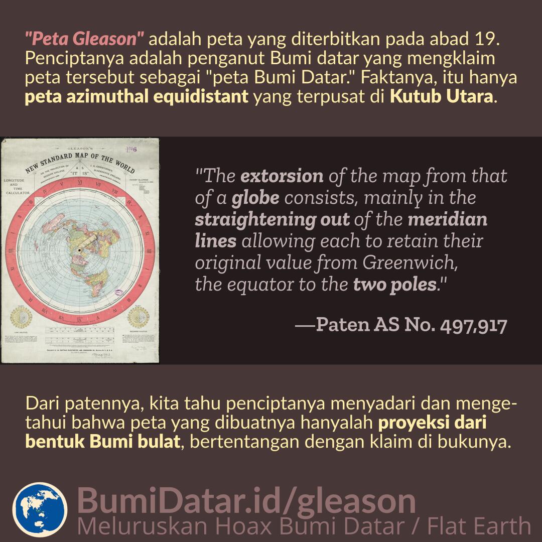
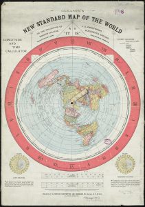
Yang disebut sebagai “peta Gleason” adalah peta yang diterbitkan pada abad 19. Penciptanya adalah penganut Bumi datar yang mengklaim peta tersebut sebagai “peta Bumi datar.” Faktanya, itu hanyalah peta azimuthal equidistant yang terpusat di Kutub Utara.
Dari patennya, kita tahu penciptanya menyadari dan mengetahui bahwa peta yang dibuatnya hanyalah proyeksi dari bentuk Bumi bulat, bertentangan dengan klaim di bukunya.
Gleason bisa saja mengklaim bahwa petanya adalah bentuk asli dari Bumi yang menurutnya datar. Namun penjelasan pada paten peta tersebut berkata lain:
“The extorsion of the map from that of a globe consists, mainly in the straightening out of the meridian lines allowing each to retain their original value from Greenwich, the equator to the two poles.” —US Patent No. 497,917 by Alexander Gleason
Dari paten yang dia daftarkan, Gleason sama sekali tidak menyebutkan Bumi datar. Sebaliknya, Gleason menyebutkan bagaimana dia membuat peta tersebut berdasarkan globe, yang sesuai dengan ciri-ciri distorsi proyeksi azimuthal-equidistant yang berpusat di kutub utara.
Gleason dan Konsep Salah Bumi Datar
 Pada mazhab Bumi datar yang populer di Indonesia, peta Bumi datar diskenariokan sebagai peta yang berasal dari elit global, tetapi dirahasiakan. Beberapa tahun lalu ada yang menemukan peta Bumi datar di sebuah perpustakaan di Boston, dan “kebocoran informasi” ini dianggap sebagai salah satu bukti “penutupan fakta” oleh elit global.
Faktanya, yang membuat peta tersebut, Alexander Gleason, adalah seorang penganut Bumi datar sejati. Dari bukunya “Is the Bible From Heaven?” dan “Is the Earth a Globe?”, Gleason menyimpulkan Bumi datar dari ayat-ayat Al-Kitab. Sama seperti penganut Bumi datar jaman sekarang, Gleason juga memilih-milih bukti, dan hanya berpegangan pada ‘bukti’ selama sesuai dengan akidahnya.
Hanya karena peta tersebut ditemukan di perpustakaan Boston, bukan berarti institusi tersebut atau pemerintah Amerika Serikat mempercayai bentuk Bumi datar.
Peta Gleason sebenarnya hanyalah sebuah peta dengan proyeksi azimuthal-equidistantu dengan pusat di kutub utara. Proyeksi azimuthal-equidistant hanyalah salah satu dari sekian banyak jenis proyeksi peta. Untuk menggambarkan Bumi yang sebenarnya yang bulat ke dalam bidang datar dibutuhkan proyeksi, dan proyeksi ini tidak akan pernah 100% sempurna.
Karena sesuatu hal, Gleason memilih proyeksi azimuthal-equidistant untuk menggambarkan idenya mengenai “Bumi datar”. Bagi Gleason dan penghuni benua Eropa atau Amerika lainnya, proyeksi ini relatif akurat untuk menggambarkan Bumi yang sebenarnya. Namun, semakin ke selatan, akan semakin tidak akurat. Bisa kita lihat ukuran Benua Australia tidak jauh beda dari negara Rusia. Padahal pada kenyatannya ukuran Rusia lebih dari dua kali lipat ukuran Australia.
Peta Gleason Pada Buku Karangannya
Pada bukunya “Is the Earth a Globe?”, Gleason menyebutkan peta ini di halaman 350:
A New Circular Map of the World, and Longitude and Time Calculator.
We have prepared a new map of the world as it is. The map is finely executed and printed in six colors. It contains all the continents and principal islands and rivers of the world, also, all the principal cities of the earth. The circle of the map is fourteen and one-fourth inches, having a time dial on which is marked in bold Roman numerals the twenty- four hours of the day and the minutes of the hour. The face of the map is provided with two detatched radiating arms from the center to the Circumference of the time dial, the arms are held together by friction, having a pivot socket at the center of the map. On the arms is stamped the degrees of latitude; by the operation or moving of these arms the relative time of day or night is quickly determined and read on the dial by the child or person who can read the multiplication table, or tell the time of day by the hands of a clock. Latitude and longitude, and the existing difference of time between any places may be determined without the aid of figures in a moment’s time after the places have been located on the map.
The great advantages to the child or pupil are these: The
whole world is before the person, with all its continents, coun, etc., in their detail and relative location, the one to the other; and so is the geography of the earth and seas established in the mind.The map should hang in the house of every family in the
land as well as every office or public place. The Publishing
Company have ready a large wall map for school rooms and public places. The company will not only supply the United States, but the world, and very soon the Globe map and Mercator’s projection will not be found. As a useful commodity they will not exist, and if any existence of them should be preserved, it would be but a memorial of that pagan idolatry from which the nations had evolved.
Dari buku yang sama, Gleason rupanya menyimpulkan bentuk peta tersebut salah satunya dari kesalahan informasi yang dia dapatkan dari seorang pelaut mengenai jarak dari Cape Town ke Buenos Aires dan Cape Town ke Cape Horn (halaman 370).
Isi buku Gleason banyak berisi kesalahan-kesalahan umum yang sering beredar di kalangan Bumi datar jaman sekarang, yang sebagian besar sudah kami jelaskan di BumiDatar.id.
Referensi
- Gleason’s new standard map of the world – Boston Public Library
- Patent 497917 – US Patent & Trademark Office
- Is the Bible From Heaven? Is the Earth is a Globe? – Alexander Gleason
- Azimuthal equidistant projection – Wikipedia